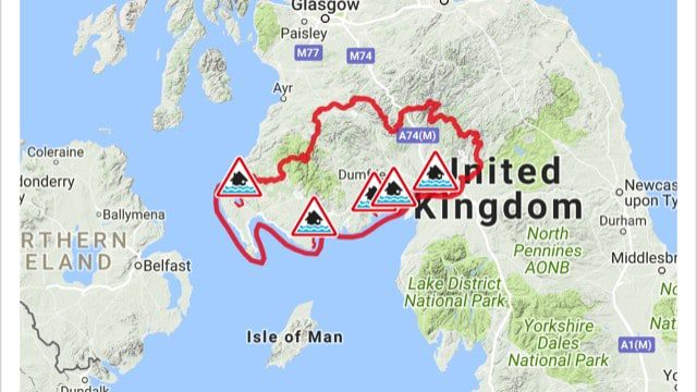
The Met Office and SEPA have both issued weather and flood warnings for the next 3 days for Southwest Scotland! On Thursday morning Storm Caroline is expected to hit our region with 60-80 mph winds which could affect local roads and transport. SEPA has also issued a flood warning for the region during this period of time,suggesting that a tidal surge and large waves will bring the risk of spray and wave-overtopping to exposed sections of the Solway coast on Wednesday and into Thursday, areas affected under this warning are Loch Ryan,Outer Wigtown Bay,Rough Firth, Southerness Point and Upper Solway Firth.
You can find all the regions high tide times by clicking HERE
After Storm Caroline has passed later on Thursday night and through to Friday and Saturday a further drop in temperature may see snow of between 2 – 20 cm hit parts of D&G also bringing the threat of Ice which may cause even more travel disruption.
 Between 06:00 Thu 7th and 18:00 Thu 7th. Storm Caroline is expected to bring a spell of very windy weather to much of Scotland and parts of the north of Northern Ireland on Thursday. Gusts of 60-70 mph are expected quite widely, with gusts to 80 mph possible over high ground and around exposed coasts. Road, rail, air and ferry services may be affected, with longer journey times and cancellations possible. Some short term loss of power and other services is possible. It is likely that some coastal routes, sea fronts and coastal communities will be affected by spray and/or large waves.
Between 00:05 Fri 8th and 18:00 Sat 9th
Snow showers are expected to become increasingly frequent over northern Scotland late on Thursday and are expected across many other parts of Scotland, Northern Ireland, Wales and western England on Friday. 2-5 cm of snow is likely for some, with 10-20 cm possible over high ground, mainly Scotland, Northern Ireland and Wales. Icy surfaces are also likely to be an additional hazard, especially overnight. Strong northwest winds may cause drifting of the snow in places with blizzard conditions possible at times across northern Scotland. The heaviest and most frequent of the snow showers will progressively become confined to northeast Scotland during Saturday. Some roads and railways likely to be affected with longer journey times by road, bus and for train services. Probably some icy patches on some untreated roads, pavements and cycle paths. Some injuries from slips and falls on icy and snowy surfaces.
During winter weather which brings snow showers, it is not uncommon for snow amounts to vary considerably across short distances. On Friday and Saturday, the snow showers could lead to snow accumulations which vary markedly across the warning area.
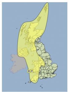
 An updated FLOOD ALERT has been issued for Dumfries and Galloway.
This alert is for coastal flooding. A surge and large waves will bring the risk of spray and wave-overtopping to exposed sections of the Solway coast on Wednesday and into Thursday. This may cause isolated flooding to low-lying land and roads at exposed locations. The times of greatest risk are around high tide early on Wednesday afternoon, but in particular around high tide during the early hours of Thursday morning.
Remain vigilant and remember, it is your responsibility to take actions which help protect yourself and your property. Advice and information is also available through Floodline on 0345 9881188. This FLOOD ALERT UPDATE is now in force until further notice. If you haven’t already signed up to receive free flood messages, please call Floodline or register online at sepa.org.uk/floodingsignup.
Your Floodline quick dial number for this area is 24300
Info Supplied by SEPA and Met Office UK