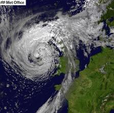
Ex-Hurricane Ophelia has moved out over the North Sea after bringing gusts of over 90mph to parts of the UK.
There have been widespread impacts across Northern Ireland, western Wales, north west England and south west Scotland. Travel disruption, fallen trees and power cuts have all been reported with many properties already having had power restored.
The strongest wind gusts were recorded on the southern edge of the low pressure through the afternoon on Monday (16 October). The tables below outline the top wind gusts recorded in the UK and the Republic of Ireland.
UK top wind gusts
| Location | Region | Gust speed |
| Capel Curig | Gwynedd | 90mph |
| Aberdaron | Gwynedd | 90mph |
| RAF Valley | Anglesey | 81mph |
| Mumbles Head | West Glamorgan | 79mph |
| Ronaldsway | Isle of Man | 78mph |
| Mona | Anglesey | 77mph |
Republic Of Ireland top wind gusts
| Location | Region | Gust speed |
| Roches Point | Cork | 156km/h (97mph) |
| Sherkin Island | Cork | 135km/h (84mph) |
| Cork Airport | Cork | 126km/h (78mph) |
| Shannon Airport | Clare | 122km/h (76mph) |
In other areas of the UK however, such as the South East of England, conditions were much more settled. It was a notably warm day particularly across the south, Manston Airport in Kent recorded 23.5°C making it the warmest October day since 2014.
Winds are continuing to ease and the yellow warning has now lapsed. However, it will remain blustery across some north eastern parts through this afternoon, and it’ll feel cooler than yesterday with top temperatures reaching 17-18C. Scotland and Northern Ireland will stay mostly cloudy with some light showers whilst sunshine across England and Wales gives way to cloud and rain in the south later.
“A brief quieter spell will last through Wednesday though interspersed with some rainfall in parts of the UK before further strong winds and rain move in from the west at the end of the week. It is too early to be sure of details but there is potential for some disruption, so it’s best to stay up to date with the Met Office forecast. Despite some speculation in the media, Storm Brian has not been named.”
There has been great public interest in the colour of the sky yesterday. This interesting phenomenon was a result of the movement of ex-Ophelia, the same southerly winds that have brought us the warmth over the weekend also drew up dust from the Sahara and smoke particles from Iberian wildfires to our latitudes. The red or yellow appearance occurs as the dust scatters the blue light from the sun which lets more red light through, much as at sunrise or sunset.
It is likely that the smoke particles alone could return on Wednesday. It is important to note that these particles will be at high altitude and are not expected to bring air quality issues at ground level, the smoke particles alone are not expected to turn the sky red to such an extent as yesterday.
Hurricane Ophelia developed to the southwest of the Azores and had reached Category 3 status over the weekend. As it moved north-east across the North Atlantic, Ophelia lost energy as it passed over cooler waters. Whilst this is an unusual track for hurricanes to take, it’s not unprecedented with ex-hurricane Gordon impacting the UK in 2006 and ex-hurricane Grace in 2009.
You can find out the current forecast in your area using our forecast pages and by following us on Twitter and Facebook, as well as using our mobile app which is available for iPhone from the App store and for Android from the Google Play store.


